
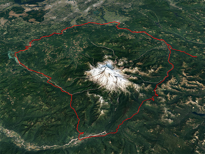
The mountain is always there but the course has changed because of nature or progress
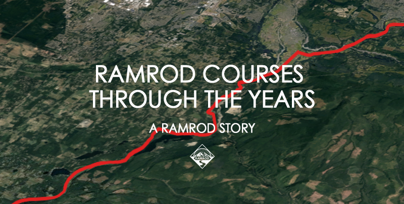
It’s really very easy. Just pirouette around the big hill.
Start in Enumclaw southbound, keep the Mountain on your left, continue for several miles and return…
…except Mother Nature, road and venue construction and safety considerations have caused a few hiccups and changes in the course route over the years. Total distance has ranged from under 150 to 195 miles, with elevation gains varying as well. Even so, RAMROD is still one tough ride whatever the length – plus on a nice day the Mountain is quite something to see close-up.
During the thirty-seven editions of RAMROD there have been five basic routes around the Mountain, plus a couple of excursions via Skate Creek Road/Packwood, and three tough out-and-back routes when disaster befell the Park and we were unable to go “around” the Mountain at all.
Note: The distance shown is taken from cue sheets or other “official” documentation where available but may be suspect, being derived from auto or cycle odometer readings. Elevation gain, when it was advertised, was quoted in round figures, and is also suspect as it was typically barometrically derived.
Current Google Maps computed distance/gain is shown in parentheses.
As always YMMV.
“Original” Course 1984-1990 (155.2 mi/10,373 ft)
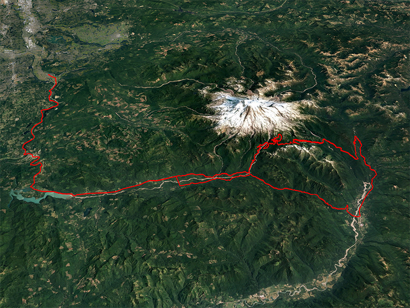
The original course layout by John Dixon, beginning and ending at the very-rustic Fairgrounds in Enumclaw, was used for the first seven years without change. Riders headed south from the Fairgrounds on 284th Ave SE and turned west on a twisty SE Mud Mountain Road to the uncontrolled junction with SR410 just before the White River bridge north of Buckley. Returning riders left SR410 at SE Mud Mountain (Dam) Road, followed it to 284th Ave SE and headed north to the finish.
View route and elevation profile on Ride with GPS
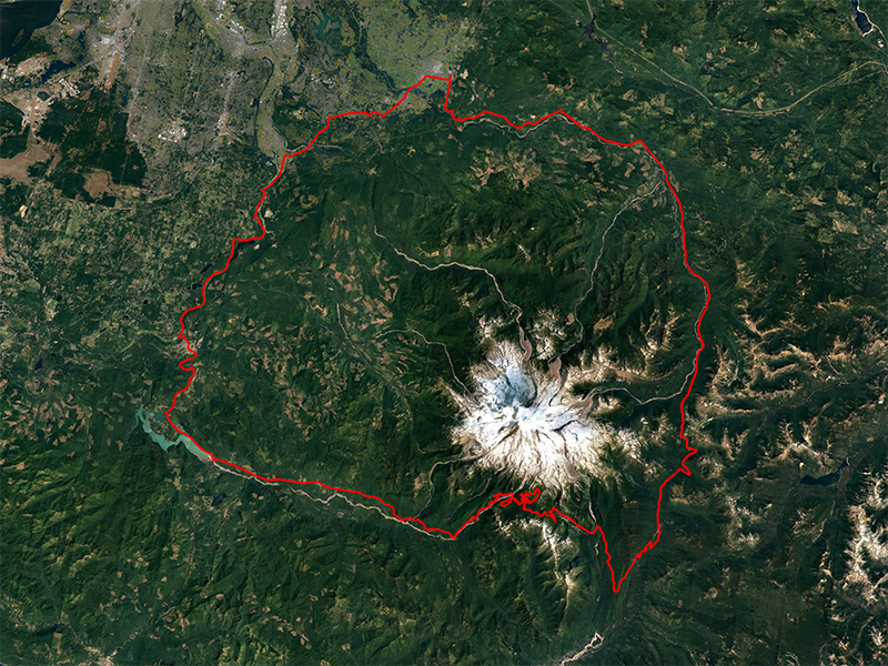
The Original
“Fastest” Course 1991 (152.8 mi/10,365 ft)
In 1991 construction forced us to bypass the “fun parts” on SE Mud Mountain (Dam) Road, resulting in a slightly shortened original course and a quick downhill run to the finish on SR410. Not coincidentally this year had the very fastest times ever recorded during the “Timing Years”.
View route and elevation profile on Ride with GPS
Skipping Mud Mountain Dam made the 1991 course the fastest route
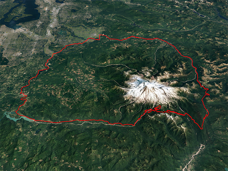
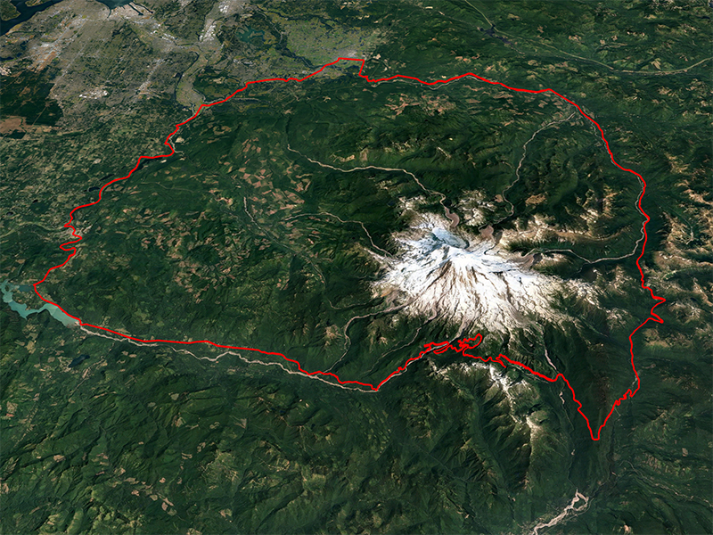
“Traditional” Course 1992-94, 1997-2002 (153.1 mi/10,306 ft)
The original course was modified in 1992 to give starting riders safer merging onto SR410 in south Enumclaw, the rest of the course was unchanged from previous years. Riders headed south from the Fairgrounds on 284th Ave SE as before but turned west on SE 456th St to the traffic-controlled intersection with SR410.
But in 1995 and 1996 construction on the east side of the Park forced us to use alternate out-and-back routes through Paradise, so no “ride around” these years. To wit…
View route and elevation profile on Ride with GPS
The Traditional Course would be the last to visit Paradise
“Killer” Course 1995 (195.1 mi/10,935 ft)
The traditional course was used, but only as far as Stevens Canyon Entrance on the east side. Instead of climbing to Cayuse Pass riders turned south to Packwood and returned via Skate Creek Road to the course near Ashford. The rest of the route was pretty much the reverse of the first 60-some miles, so it was kind of a “Loop Below Mount Rainier in One Day” course. 195 miles is a long way to go and the thought of all those extra pedal revs made many riders think twice – starts and finishes were down by a hundred from the previous year.
View route and elevation profile on Ride with GPS
At 195 miles, 1995's Killer Course was RAMROD XL
“Not-So-Killer” Course 1996 (164.1 mi/10,011 ft)
Still the “Killer” Course but we took pity on the riders by moving the start/finish to Orting, shaving 29 miles off to a still-substantial 166. It didn’t help, as even fewer riders started this year compared to 1995. The heat wave engulfing the area probably didn’t help much either.
View route and elevation profile on Ride with GPS
1996's course began and ended in Orting
“New Traditional” Course 2003-05 (152.6 mi/10,300 ft)
The traditional course layout was retained but the start/finish line was moved to Enumclaw High School. This change brought with it: Lots of parking! Grassy places to sit! Showers! real, non-generator Power! Breakfast! and a very clean and workable start/finish area – all very Modern. The riders loved it, the organizers loved it, even the school loved it. We still do - and intend to return to the High School when their construction is complete, hopefully in 2019.
However, all good things must be punished – and in 2006 we lost the final climb to Paradise due to the complete reconstruction of the Visitor’s Center complex. As events unfolded riders never again saw Paradise pavement unroll beneath their wheels and the change became permanent. So we now have….
View route and elevation profile on Ride with GPS
The New Traditional course was the first to start/finish at Enumclaw High School
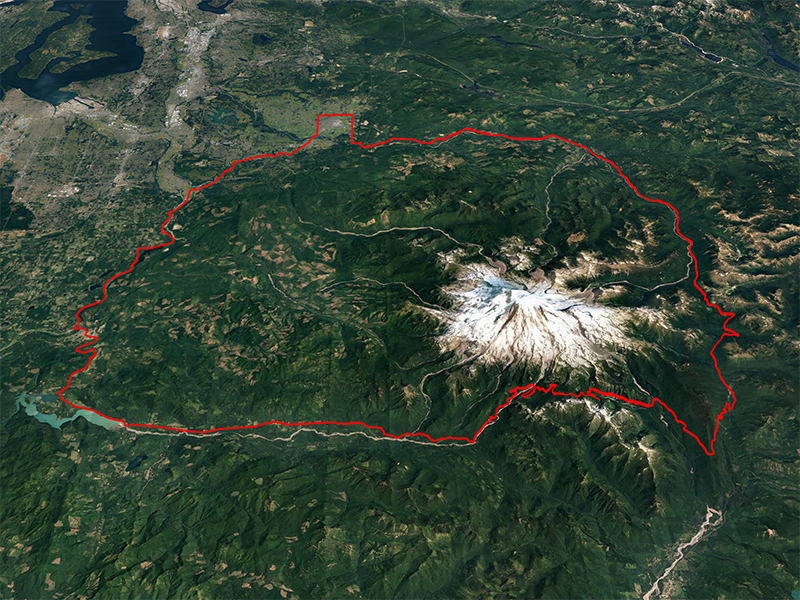
“Modern Traditional” Course 2006, 2008-13, 2015 (148.4 mi/9,728 ft)
The new traditional course, but with the riders bypassing the final Paradise climb loop. We now call Inspiration Point the summit of the Ride, but the views of Paradise and the Mountain make a stunning backdrop for riders pausing, and posing, there.
But in late 2006 Mother Nature unleashed such fury on the Park that riders had no chance of going anywhere near the south side in 2007, and in 2009 and 2014 reconstruction of roadways on the east side made it impossible to go through the Park proper. Thus some serious detours…
View route and elevation profile on Ride with GPS
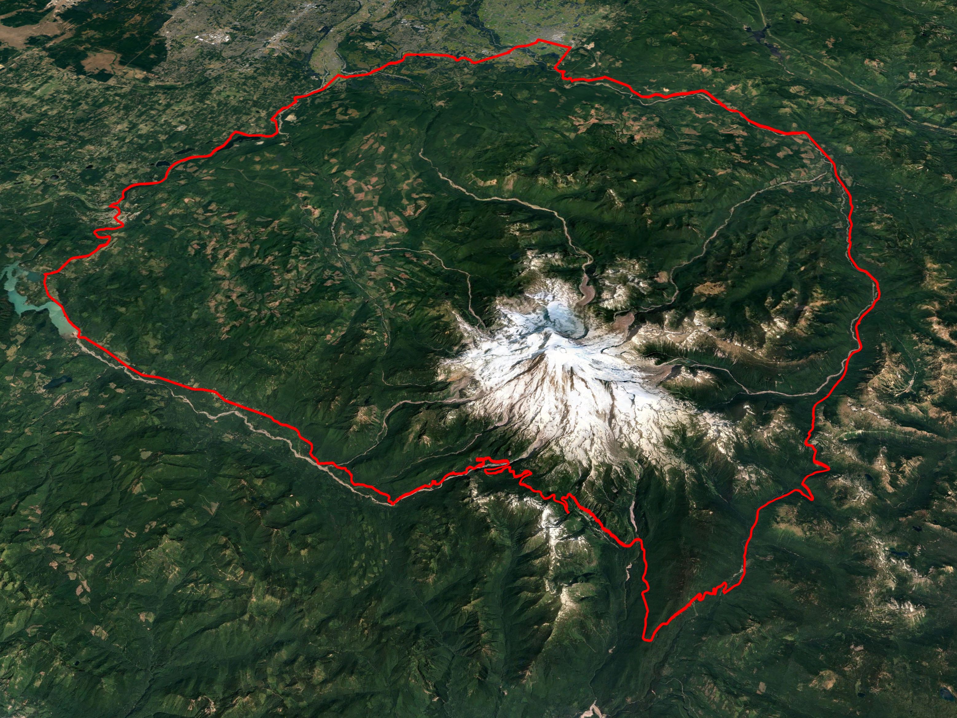
The Modern Traditional route is the current standard route for RAMROD
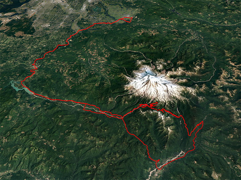
“Chicken-foot” Course 2007 (143.5 mi/10,962 ft)
And now for something completely different. No going “around” this year, floods in the Park wiped out the road beyond Nisqually in many places and severely damaged infrastructure in almost every developed area. Skate Creek Road was also heavily damaged. So, in an effort to retain some flavor of the Ride and to keep the challenge in place, we opted to do an out-and-back on the north side of the Mountain. Everything but the start/finish changed, riders reversed the finish stretch to join SR410 near the Fairgrounds and proceeded on a leisurely ride to the north Park Entrance and UP to Sunrise, then DOWN and out of the Park and UP to Crystal Mountain Resort, then DOWN and back toward Greenwater, pausing only to do a nasty out-and-back on FS70 (the one with the 12% pitch both ways) and then a quick bite at the Deli, now located at the Greenwater Fire Station. We also laid on an extra food stop early in the ride because, though the course was shorter than typical, the total elevation gain was almost 11,000 feet. It was an interesting day for all, but for many riders their first look at the glories of Sunrise, and the hairy descent, were a real treat.
View route and elevation profile on Ride with GPS
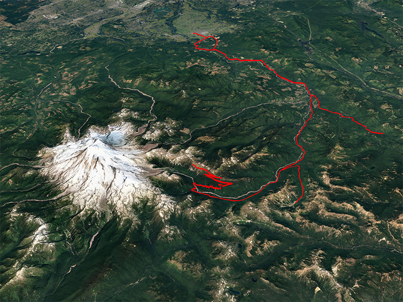
Flood damage in the winter of 2006 dramatically altered the 2007 route
“Skate Creek” Course 2009, TTMS Edition 2022 (158.5 mi & 162.3 mi/9,815 ft)
Going the long way around this year. The modern course was followed past Ashford, then turned south on Kernahan (Skate Creek) Road to Packwood, then north on US12 to the SR123 intersection and into the Park from the south near Ohanapecosh, rejoining the modern course at the Stevens Canyon Entrance intersection. To add to the fun a short jaunt up to the Crystal Mountain Resort was added. The most significant logistical challenge was traffic control in and around the food stop north of Packwood, and rider comfort during the record heat in the high 90’s. The course was a bit longer than typical but about the same elevation gain.
Due to significant construction in Steven's Canyon, Skate Creek returns in 2022 but with the start/finish line at Thunder Mountain Middle School adding an extra 4 miles.
View route and elevation profile on Ride with GPS

The first Skate Creek course from 2009
“Skate Creek EFI Edition” Course 2014 (166.4 mi/10,010 ft)
Just what it says. The 2009 course had been fine, but the organizers decided to substitute an “optional” out-and-back using the FS70 segment from the 2007 “Chicken Foot” course instead of the climb to Crystal Mountain Resort. Shades of Orting 1996! 168 miles and a full 10K of elevation gain. Riders of the FS70 segment were awarded an “EFI” (Every F*** Inch) pin for their exertions - most riders took up the challenge.
View route and elevation profile on Ride with GPS
Skate Creek was used in 2014 but an EFI 'kicker' was added towards the end
“Modern Traditional Thunder Mountain Edition” Course 2016-19 (152.7 mi/9,845 ft)
The modern course with an alternate start/finish. Total reconstruction activities at the Enumclaw High School banished any thought of its use as our staging area. The school district authorities were kind enough to suggest an alternative, Thunder Mountain Middle School, located north of the city center. The venue is less compact and parking is scattered throughout the city, but the facilities are newer and nice, and the staff is most welcoming. We’re here through 2018, and *possibly* for 2019, but are itching to go back “home” to the new High School and the Modern course as soon as possible. The move added some traffic control kinks, a very few miles and the tiniest bit of elevation gain.
View route and elevation profile on Ride with GPS
Construction at Enumclaw High School moves the Start/Finish north to Thunder Mountain Middle School
Courses By The Numbers
Eleven different routes have now been used in the first 37 years of RAMROD. Here they are in order of times used from most to least...
1. Traditional - 9 years
2. Modern Traditional - 8 years
3. Original - 7 years
4. Modern Traditional TMMS Edition - 4 years
5. New Traditional - 3 years
6. Skate Creek EFI Edition - 1 year
7. Skate Creek - 1 year
8. Chicken Foot - 1 year
9. Not-So-Killer - 1 year
10. Killer - 1 year
11. Fastest - 1 year
We’d like to thank RAMROD super-volunteer, RAMROD veteran and former RCC President Thomas Killion for taking the time to assemble this course history information!